From Sunday, March 2, 2014
I'm developing an obsession with exploring the vast quantity of US Forest Service Road in the Southeast via mountain bike. If you pick the right routes, Forest Service roads offer thousands of feet of climbing combined with good views and plenty of solitude. My favorites are those that run at high elevations and have enough openings in the trees to allow for looking at the spectacular landscape of the Appalachian Mountains. After reviewing my map of the Ocoee region, I took a notion to ride FS Road 77 on Chilhowee Mountain in Cherokee National Forest, Polk County, Tennessee.
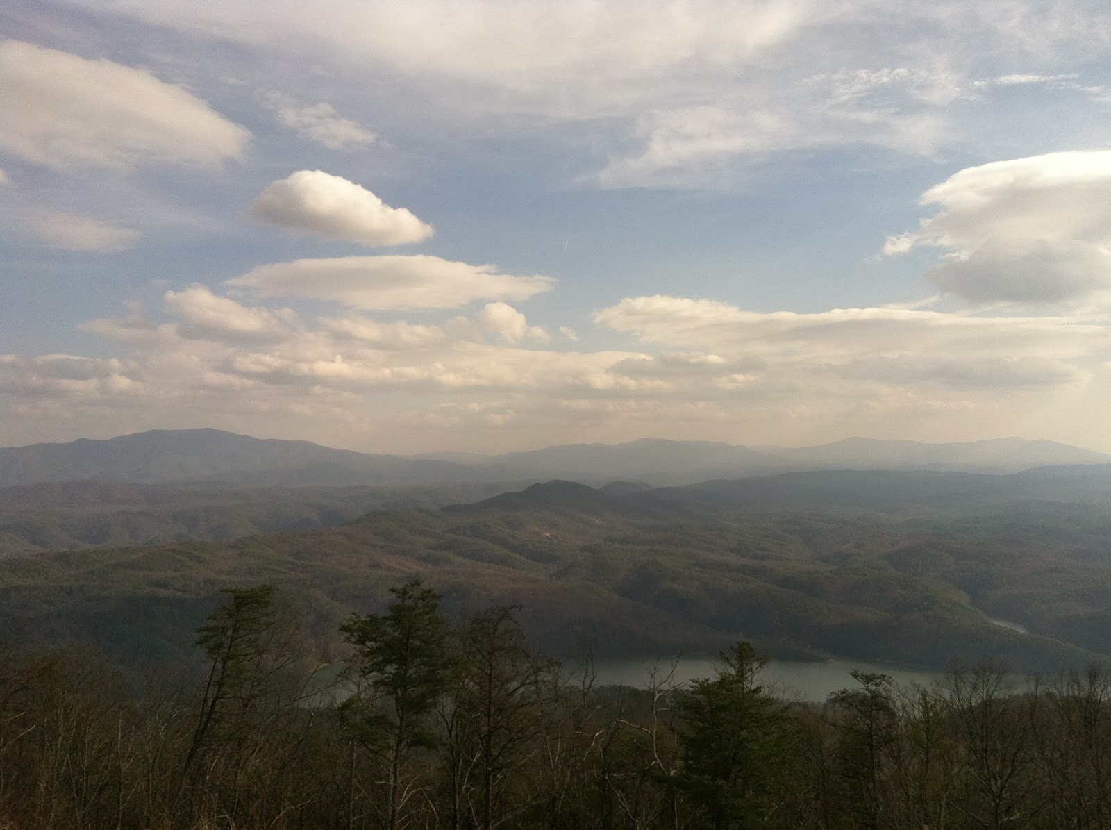 |
| The Blue Ridge Mountains from Forest Service Road 77 on the flanks of Chilhowee Mountain. This is on the paved section of road and is one of the earlier views you come to if you drive up 77 from US Highway 64. The lake below is Parksville Lake, also known as Ocoee Lake #1, a reservoir on the Ocoee River. |
 |
| Slightly different angle with Big Frog in the center. Chilhowee Mountain is in Tennessee but much of what you see here is Georgia. |
It's about an hour drive from my house in Ringgold, Georgia to get to the top of the mountain. I parked at the Chilhowee Recreation area, a very nice fee use area with seasonal campgrounds, a small lake, and an elaborate trail system with many trails open to bicycles. My intention was to first ride one of the major trails over to a waterfall that drops off the side of the mountain, Benton Falls, before hitting road 77, but a trail runner in the parking lot who also mountain bikes reminded me that it was significantly downhill to get to the falls. Therefore it would be a significant climb to get back to the car. Since I had already visited the falls before, I decided to hit the road first to make sure I had the legs to complete the ride on 77. If I had realized I was going to do that I could have saved the parking fee by just parking along the road, but it was only $3 anyway.
The climb out of the parking lot at the Chilhowee Recreation area gets you off to a bad start. I kind of wish I had ridden some of the easy trail around the lake to get warmed up because I burned my leg muscles a little bit on the way up to FS Road 77 and that would haunt me all day.
 |
| A view of the Blue Ridge Mountains from Chilhowee Mountain. This view was actually on the entrance road to the Chilhowee Recreation Area, where I left my truck. |
Road 77 is paved from Highway 64 where it intersects next to the Ranger Station for the Ocoee Ranger District but it turns to gravel at the turnoff to the recreation area, which suits me just fine. Within a short distance I was cruising along on relatively level gravel road with some nice views, although partially obstructed by trees. The elevation around this area is about 1900 feet above sea level. I would imagine the views are more restricted from late spring through mid-fall due to foliage but I was enjoying my late winter ride, which pretty much went along the crest of the Blue Ridge front, with huge views to the left into the broad Tennessee River Valley and view of opposing slopes of Chilhowee Mountain and other nearby, taller mountains such as Little Frog Mountain and Big Frog Mountain (4224 ft above sea level - 1287 m). Big Frog is the westernmost mountain above 4000 feet before the mountains of the Big Bend region of Texas or the Black Hills of South Dakota. The views were a bit hazy when I started due to overcast but cleared up and were spectacular on the return ride.
 |
| The US Forest Service has been replacing signs with these new, colorful signs on complex natural stone mountings. I think I miss the brown but maybe I'm just an old fool. Also, we know what brown means, don't we? This is where the gravel section of 77 begins, also known as Oswald Dome Road. |
 |
| Big Frog Mountain as seen from FS Road 77. As usual the clarity and sense of scale are lost in the photography. |
Eventually I came upon a large rock outcropping that rose on the left (western) side of the road and it looked like a hangout spot for locals. Unfortunately it is a bit defaced by graffiti and the small parking area is littered with broken glass and so forth but it still looked worth the climb. I actually saved the climb up for the return trip but either way I would recommend stopping here if you don't mind some rock scrambling. It's nothing you will ride a bike up but the views are worth it. There are sweeping views of the Tennessee River Valley and the Blue Ridge Thrust Front, a geological formation where the Blue Ridge Mountains dramatically rise above the relatively flat valley of the Tennessee.
 |
| . . . from the rock outcropping. This is the trail, such as it is. Difficult and risky hiking in bicycling shoes with metal clips on the soles. I found a less exposed route on the way back down but it wasn't a whole lot safer. |
 |
| The view from the massive rock outcropping. I was headed up to the summit with a radio tower on it on the right, Oswald Dome. It's a monster climb on gravel to get up there. This is the Blue Ridge Front. To the left, the Tennessee River Valley and the Ridge and Valley province, to the right, the Blue Ridge Mountains. The mountains in the distance at center are the Unicoi. |
 |
| Slightly obstructed view of Big Frog Mountain and the Cohutta Range (very faint just to the right) from the ever-present power line cut. Seems like every National Forest in the Southeast is diced up by the path of electricity transmission lines. |
Unfortunately the road drops down significantly into Lillard Gap separating the bulk of Chilhowee Mountain from Oswald Dome thus adding to the climbing required for the route. After passing the gap you start the real climb. My legs were already burning by the time I got to the low point at Lillard Gap where 77 turns down the mountain and I was to take the spur 77C up Oswald Dome. What followed was a suffer fest, the likes of which I have rarely endured since I started mountain biking. I've had a busy winter and just haven't had the time to get out and train on my bike, and I dislike using stationary bikes to train. I paid for the lack of fitness. The Strava track shows sections with over 20% grade and a 1068 foot climb for the segment - a category 2 climb.
I climbed and climbed and climbed until finally I had to stop and rest. I consider that a personal defeat because I'm usually pretty good at climbing without stopping, but sometimes you just have to stop. I pushed my bike a little bit and then got back on and rode a while. The cycle repeated a couple more times until I got to the top. It's necessary to go around a closed gate that leads up to the radio towers at the summit. That gave a welcome reprieve to take a photo.
 |
| Finally made it to the gate up to the gate on the road that leads to the summit of Oswald Dome.It get steeper than what you see here. |
 |
| Proof of the summit. Just over 3000 feet above sea level. Really windy up there, with no open views, just some radio towers and the gratification of having made it. |
I stopped to tank up on water at the top from my CamelBak, and to catch my breath and take a couple more photos before beginning the descent. As usual the way back down passed extremely fast but I braked carefully to avoid crashing and could not resist stopping to take more photos, since the atmospheric conditions had improved as the day grew long (most of the photos in this post were actually taken on the return trip). I'm not into bicycle racing so I don't pay much heed to the time penalties for caution and photography:-) It seemed like in no time at all I was back at my truck trying to recover and plotting a trip to the Whitewater Grill on Highway 64, one of my favorite local restaurants for after-ride feasting (and after whitewater feasting - I also paddle a whitewater kayak on the Hiwassee and Ocoee Rivers). It was a scenic day and a ride I'll remember for a long time. Spare photo dump and Strava track below . . .
 |
| Bonus photo taken on the way back down the mountain. The small peaked mountain in the center is Sugarloaf. The dam of the lake is right at the base of the mountain. The Ocoee River sneaks between Sugarloaf and the nearer Little Mountain to drop out into the Tennessee River Valley. In the hazy distance are the Ridges of the Appalachian Valley and Ridge province. |
Here is the Strava track.

Comments
Post a Comment