Normally I only write about new or unique experiences but there are some very good trails I first rode on a mountain bike before I started blogging. I revisited a trail today that is an old favorite of mine and I decided it was well worth writing about. Familiarity does not always breed contempt. My favorite local mountain bike ride that is true
singletrack in a National Forest is the Brush Creek Trail, just off Highway 64 between Ocoee, Tennessee and Ducktown, Tennessee. The trail winds away from the highway around the side of the complex Sheep Top (2020 ft), a small mountain attached to the nearby Little Frog Mountain, along the drainage of Brush Creek and the right bank of the Ocoee River, now a reservoir flooded behind the hydroelectric Ocoee Dam #3 of the Tennessee Valley Authority. Brush Creek features exceptionally smooth, buff trail by East Coast standards as well as spectacular views and a wilderness experience that cannot be found in the busy suburban parks in and around Chattanooga. The entire trail is located within the boundaries of Cherokee National Forest, Ocoee Ranger District and is just over an hour drive from my house.
 |
| The view from Boyd Gap. This photo was taken in Spring 2012 on a previous ride. That is Big Frog Mountain on the right, 4224 feet above mean sea level. |
There are multiple access points to the trail but I like to start at the main trail head on the highway where my vehicle will be parked within sight of the busy road. Break-ins are more of a problem in National Forests than one might think due to infrequency of law enforcement patrolling. If you have the option, it's best to park in a well traveled lot.
From the trail head, the trail runs downhill sort of in the wrong direction and it's necessary to ensure you don't miss the greater than 90 degree turn to stay on the trail and not wander off onto another connecting hiking trail. If you've made the right choice, you pass under the road bridge heading in the opposite direction from your start and begin riding along very smooth, flowing trail that is surprisingly sunny and open, with views to your left across the valley of Brush Creek, although the stream itself is not visible from the trail.
 |
| A typical section of the Brush Creek Trail. You can see the open, sunny nature of the forest due to the thin canopy here. Actually the canopy is completely absent in places but I don't have a photo. This was taken October 17, 2010 but it hasn't changed significantly. |
In this area you are likely to encounter deer browsing in the grassy areas. The forest here has obviously been cleared in the past, due to road construction as well as logging. I've seen signs of a fire on past rides, although the evidence has faded and it is possible that it was a controlled burn. At any rate the scene is sunny and grassy and very reminiscent of the type of riding found in the Rocky Mountains.
The trail intersects some connectors that provide shortcuts back up to the highway. These are convenient on the return trip if you want to cut short your ride a little. These intersections are obvious and currently are well marked so it's pretty easy to stay on the main trail. The trail weaves in and out of ravines, maintaining fairly constant elevation with just some minor rolling hills. As a consequence, it is perfectly suitable for beginning mountain bikers.
One of the ravines has a healthy creek flowing through it that must come out of a large spring somewhere up in the forest because I've never known it to be dry, even during deep drought. There are well constructed bridges over this branch and a couple of other minor streams that flow out of the ravines. You will start getting warmed up about the time the trail turns above the confluence of Brush Creek with the Ocoee and you start to get good views of Ocoee Lake #3, with the accompanying mountains over on the far side. It's a beautiful little lake and is extremely isolated from civilization. Sometimes you are lucky and see waterfowl cruising on the lake. It's a serene view.
 |
| A view of the rarely seen Ocoee Lake #3 with the slopes of Big Frog Mountain just visible in the distance. Photo taken October 17, 2010. That's a fishing boat in the distance but most times there are no boats. Speed boats are banned on the lake. |
The trail winds through several stands of pine and the trail is covered with a bed of pine needles, muffling the sound of your passage and smoothing the trail even further. Is there anything better than riding a bicycle quietly in the shade of pine trees on a smooth mat of needles? It's a question that came to mind this afternoon as I was riding.
I've periodically startled wild animals of various sorts on the Brush Creek Trail, with turkey and deer being common. Bears are typically reported from this trail so I'm always aware of the possibility of an encounter but I have not had that experience yet. I started a herd of deer on the return ride today, their white tails raised high as they bounded off across a small meadow. It was a beautiful moment,although I was sorry to frighten them.
The trail is a skeleton key loop, there being a short spur near the end of the trail that circles back over a haunch of the mountain to rejoin the main trail, but I always take a connector trail that climbs to Boyd Gap first. The gap is the original point where the old Copper Road once went through a cut between Sheep Top and the rest of Little Frog Mountain. The trail now goes through the cut but the highway has been moved over to a new, massive cut on the other side of a forested hill. The climb from the Brush Creek Trail up the connector to Boyd Gap is short but stiff and I have to constantly remind myself to keep moving and choose my line carefully to avoid momentum-killing rocks and roots in order to make the climb without stopping. When my fitness is up it's easy but today it was difficult.
 |
| The original road cut at Boyd Gap. The old Copper Road used to run through here. It was used to haul copper from the mines near Ducktown, Tennessee down to the Tennessee River valley. From October 17, 2010. |
When you finally break out of the old road cut into the Boyd Gap overlook parking lot, you are greeted by one of the best views in the region. You can see the Ocoee River far below, some 700 feet or more down, and on the other side of the river, the 4224 foot summit of Big Frog Mountain, the westernmost 4000 foot mountain until you cross the Great Plains. Also visible are more distant mountains of the Blue Ridge including Chilhowee Mountain (2618 ft) and Oswald Dome (3020 ft).
 |
| The view west, approximately downstream over the Ocoee River Gorge. I believe the crest just to the right of center is Oswald Dome. Photo from October 2010. |
 |
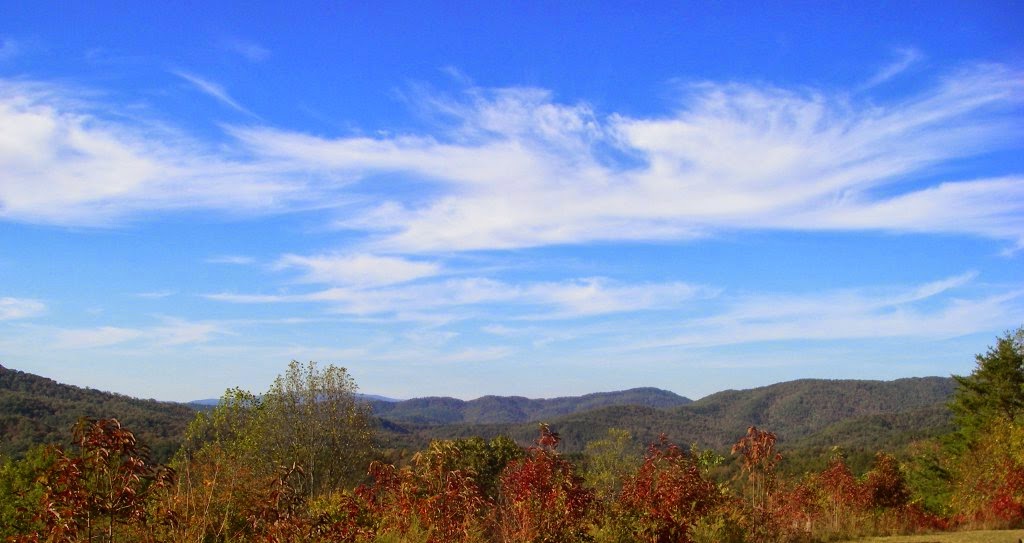
| The view the other directioin from Boyd Gap, similar to the one at the beginning of this story but taken in October 2010. |
On the way back to the car, it is possible to take a shortcut on the road from the overlook to Highway 64 and a short, fast downhill will bring you back to the trail head, but I haven't done that in quite a while. It cuts off several miles of great singletrack in the wild! Instead, I usually ride back down the connector to the Brush Creek Trail and take the spur to the left to complete the skeleton key loop. The spur features a steep, fast descent with rapid fire switchbacks so be careful not to let your speed get away from you. After the spur rejoins the main trail, turn left and you are retracing your mileage back to the car and a couple of side trails that follow fire roads back up to the highway are available to cut off some of it if you are feeling tired. I followed the main trail all the way back to my car and was sad when it was over. It's a great trail and has been one of my favorites since I started riding it 4 years ago. I'll be back!
A Note Regarding Elevations
I apologize if any of the elevations are different than figures you have seen elsewhere. I've noticed over the years that different sources provide different peak elevations for mountains. This problem definitely dates back to the era of print media but disappointingly has not improved since the advent of the internet. Apparently measuring height above mean sea level remains a difficult task.
Source for elevations: http://listsofjohn.com/PeakStats/search.php?c=1194
Photo Dump
 |
| The dry Ocoee riverbed. It's "dewatered" most of the time due to the hydroelectric dam, which diverts water through a tunnel to a powerhouse far downstream (and therefore downhill). This photo was taken today and you can see why I chose to use photos from previous rides. The lighting was terrible and the trees are still bare, although truly it was still beautiful in person. |
 |
| Yet another view of Ocoee Lake #3 from Fall 2010. |
 |
| A similar view to one of the photos above of Ocoee Lake but taken May 28, 2012. |
 |
| Fall colors at the Brush Creek Trail, October 17, 2010. |
 |
| The new road cut at Boyd Gap where Highway 64 runs towards North Carolina. Some of those peaks in the distance are likely the Nantahala Mountains but I'm not positive. Also might be the Blue Ridge Mountains of Georgia, which is not far away. Photo from October 2010. |
Here is the Strava track. I'm still pretty slow from a relatively inactive winter but my fitness is definitely improving.


Comments
Post a Comment