 |
| Vivid Autumn color in the Unicoi Mountains. |
I really wanted to get out last weekend to some high country before the snow closes everything out for the winter. In the Southern Appalachians, there is usually some low-altitude hiking to be found all winter but I prefer the more alpine regions above 4,000 feet and you really have to get it in between April and October or you are likely to run into ice and snow. I made plans to head up to the Cherahala Skyway in search of meadows with sweeping views. Since the leaves are changing right now, it seemed like a good opportunity to view the fall foliage as well. I invited several people but only my friend Jenny Taylor took me up on the offer. We made plans to meet at the Nantahala River where she had been paddling whitewater the previous day to drive up onto the skyway to Huckleberry Knob, which seemed to offer the best opportunity for wide views.
 |
| The Cherohala Skyway on the Tennessee side of the Unicoi Mountains. |
The Cherahala Skyway is a highway that was constructed along the crest of the Unicoi Mountains (part of the Appalachian chain) along the Tennessee-North Carolina border just southwest of the Great Smoky Mountains. It climbs to over a mile above sea level and offers numerous views and trailheads for hikes into the high country of the Unicois. The name "Cherahala" is simply a portmanteau of Cherokee and Nantahala, meaning it runs through Cherokee National Forest on the Tennessee side to Nantahala National Forest on the North Carolina side. It is less well known than some other scenic drives such as the Blue Ridge Parkway, but I find it to be as beautiful as anywhere I've been in the eastern half of the United States.
 |
| Typical Cherohala Skyway road. Motorcyclists favor this highway. |
 |
| A typical view from the Skyway. It was a little too cloudy and hazy for ideal viewing conditions. |
 |
| A wider view into lower country. |
The hike on Huckleberry Knob is pretty easy and heads up very "unimproved" double track onto a grassy meadow, referred to colloquially as a "bald." I interpreted the presence of the double track to indicate that the Forest Service is probably taking vehicles up onto the bald to mow the grass and keep it open. In the 19th century these balds occurred naturally but in the 20th century they started to become overgrown. No one is sure why the balds are filling in but the Forest Service maintains the balds in order to maintain the previous character of the high country. I'm never sure about the value of doing something like that but I certainly appreciate the views.
 |
| Uh-oh! Fogged in at the trailhead. It's well above 5,000 feet above sea level so there is always a good chance this will happen on a given day in the rainy Southest. |
Unfortunately from the trailhead on it was apparent that we were up in the cloud deck and when we arrived on the crest of Huckleberry Knob, we could initially see nothing. This was later interspersed with cloud and fog obstructed views of indistinct mountains. The weather conditions could have been slightly better.
 |
| The trail consists of primitive fire road / doubletrack. It's a pretty easy hike although it gets overgrown with grass once you break out of the trees. |
 |
| The views were obstructed, clouded, opaque, and several other adjectives including the impolite. |
 |
| A view showing the entirety of the balds at Huckleberry Knob. |
 |
| The clouds closed back in. You can see the double track vehicle path here. |
We hiked out along the balds, stopping to take some photos and enjoyed the late season wildflowers that remained, the fall leaf colors, and the tall grass waving in the wind. Despite the obstructed views, I always enjoy being on top of a mountain and the cold wind didn't interfere with my experience.
 |
| Not a sweeping view, but still worth viewing. |
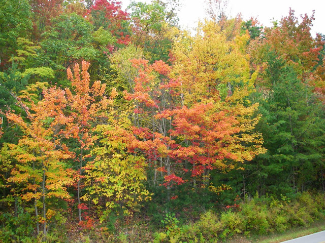
We hiked around on some of the more well-beaten paths and waited for clearing but it eventually became obvious that it simply wasn't going to clear up, so we hiked back to the car and continued along the Skyway towards Tellico Plains, Tennessee to get something to eat, stopping along the way to enjoy some views. After we dropped below the cloud layer, it became apparent that the colors were more vivid on the Tennessee side of the Unicois, especially around 2500 to 3000 feet and we saw some of the brightest reds and most vivids yellows I've ever seen in Fall leaves.
 |
| Bright colors just below the overlook, which was around 3000 feet above sea level. |
 |
| The highway was a corridor of color in places. |
 |
| Vivid color around a picnic area. |
The low cloud layer was a disappointment but we still got to see some great fall colors and beautiful mountains. As a bonus, I finally saw a bobcat in the wild for the first time on the way home along Highway 64 near the crest of Boyd Gap. Unfortunately I was moving too fast to get a photo and the cat skittered off into the forest when my car got close. Still, I'll take the experience over the photo any day of the week. I've been trying to see a bobcat in the wilds for decades so it's nice to get that crossed off the list.
Another weekend day well spent!
Post Script Riddle: When is a bear-proof trash can not bear proof?
Answer: When you don't close the lid until it latches.
 |
| Bear sign! Also Redneck sign. Note the dents from a shotgun blast. This trash can has had a rough time. |
 |
| I make these to be claw marks. |
Until next time . . .


Comments
Post a Comment